Skip to content

Category: hiking

Mount St. Helens Weekend

So after all the traveling we’ve been doing this year, it has been very nice to be home, here in Washington, for a few weeks in a row.  Summer has been a bit stressful, which is evidenced by the lack of blogging, but things have calmed down a bit.  We’ve also had a very slow start to our summer this year.  We’ve dubbed it “The Spring That Wouldn’t End”.  As all of my East Coast friends have been melting into puddles in the extreme heat, we’ve been rocking jeans and hoodies ’till about last week.  ::sigh::

However, the sun has FINALLY decided to show up, and Tom and I fled to the mountains, as we often do.  Due to the aforementioned late spring, we also have a heavier snow pack than usual, and one that’s been hanging around for a while.  Now, growing up in Virginia, I never had to worry about things like “snow pack” effecting what I wanted to do on a summer weekend.  It’s summer, therefore there shouldn’t be snow, RIGHT?  Not so out here.  Summer arrives, and hikers patiently (or not) wait for their favorite hikes to melt out so we can get going again!  This year, that patience is wearing thing, as it is August, and many of the hikes we normally do in June still havn’t melted out.  So, we’ve been forced to look for other options.  We’ve done some pretty hikes in eastern Washington, on the other side of the Cascade range, which if you didn’t know, is basically a desert.  Last weekend, we opted to stay on the west side of the Cascades, however, and head down to the Mount St. Helens area to do some hiking or backpacking.


There is limited and very confusing information about backpacking in the Mount St. Helens area.  It is registered as a National Volcanic Monument, which would make one thing that it is run by the National Park Service.  Not so.  It’s run by the National Forest Service, which generally has much more limited information about backcountry conditions, permits, etc.  You really have to talk to a human to figure it all out, except it’s really hard to get a human on the phone.  Ok.  So we decided to go anyway, and check in at the Forest Service Ranger Station on the way.  They were very helpful, but very busy, with people asking for everything from good motorcycle routes to mushrooming permits (yes, apparently this is a thing).  We secured our backcountry permit, which allowed us to camp in the Mount Margret Backcountry around Mount St. Helens.  We were assured that the route we planned would be snow free and all would be well.  Yay!

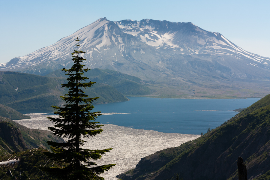
We headed in towards Mt. St. Helens, and were soon greated by spectacular views.  The day was amazingly clear, and we had unobstructed views right into the crater.  I had never been so close to the volcano before, and it was pretty impressive to see the destruction it caused when it erupted.  The land in the blast zone near the volcano has been almost completely preserved so that researches can study the regeneration of the forest around an active volcano.  There are still stands of trees that were blasted flat by the eruption, laying where they fell over 30 years ago.  Spirit Lake, which lies right in the blast zone, is still filled with logs that were blasted into it all those years ago.  It’s quite a site to see.


Our planned route was up Norway Pass to Panhandle and Obscurity Lake and to camp at the lakes for the night.  We packed up our backpacks and headed out.  The trail is steep and exposed to the direct sun for most of the way up to Norway Pass.  As the day was clear, we had amazing views of the nearby Cascade volcanoes:  Mt. Rainier, Mt. Adams and even Mt. Hood off in Oregon.  It was quite a treat for folks who have been living in a cloud more than normal this year.  As we got up to Norway Pass and dropped down slightly , Mt. St. Helens came into view.  Woah.  We had views right into the crater.  There was definitely a moment where I thought about what would happen if the volcano decided to randomly erupt just then, but then rational thought regained purchase, and we moved on.


We continued to climb and soak up the sun and views until we go to Bear Pass, where the trail dropped over the north side of the ridge…right into a very steep snowfield.  We had not brought snow gear, so we needed to reassess.  Tom bushwacked down a bit past the snowfield where we could see the trail came out again to see if was passable further along.  He came back, reporting that there were two more steep snowfields that were probably not safe to cross.  We were slightly frustrated that we hauled up all of our backpacking gear to not be able to camp, but realized that sometimes you just have to turn around.  We spent some more time hanging out on the ridge, looking at the mountains and the wild flowers before we headed back down.


That night we camped at the Iron Creek NFS campground, which was huge, but nice.  I was feeling a bit pouty about being hot and dirty and not being able to backpack to a nice cool lake and just wanted to go home.  Tom convinced me that staying in the nice campground was preferable to a 3+ hour drive home at 7:30 at night, and he was right.  The next morning, we decided to hike up Goat Mountain, which is a short day hike near the volcano and our campground.  The trail is quite steep, gaining 1,600 feet in about 2 miles, but the forest is nice and cool.  Once we got to the ridge, we realized that the low lying clouds were pretty much obscuring all the views of the local mountains, but there were nice wildflowers to look at and the ridge was pleasant.  After the bugs found us though, it was all over.  After a quick stop at a lingering snowfield to cool down, we were off.  We headed down off the ridge and back to our car.

It was a great weekend, and I had a great time exploring a different part of the state.  We will be back!

6 Comments

New Zealand: Arthur’s Pass National Park

Many abject apologies for the total lack of blogging recently.  We had some server difficulties which made it impossible to access pictures for about a month. Things are back online now, and there should be more frequent updates!

After leaving Abel Tasman National Park on Christmas Eve, we drove south through the interior and finally along the west coast…..and drove, and drove, and drove.  The south island is far less populated that the north island, and this is evidenced by the total lack of traffic, the overabundance of sheep and cattle, and the one lane bridges, (more on these next time).  Our destination was Arthur’s Pass National Park. The weather was volatile, as usual, but we did get some partial clearing and a rainbow or two along the way.

After turning away from the coast, and heading back towards the center of the island, we were aiming straight for the Southern Alps.  This is the mountain range that runs the length of the south island.  It is large, remote, wild, virtually uninhabited and has very few passes over it.  As you may have guessed, Arthur’s Pass is one of them.  Eventually, we started our climb up through the mountains.  It was late in the day, and a mist and fog was laced through the valleys and snaked around the peaks.  We started looking for Gollum to poke his head around the next jagged rock outcropping looking for the One Ring.

We finally arrived at the tiny village of Arthur’s Pass, and tried to seek out a Christmas Eve service.  As it turns out, the tiny chapel in town only has services on Sunday mornings, and Christmas is no exception.  So no Christmas carols for us.  This was  a pretty big blow for me.  I had never been away from family before on Christmas, and never missed the Christmas Eve church service.  To me, it’s an integral part of Christmas, and I wasn’t going to get it this year.  There were tears and I threw a pretty big pity party for myself.  Luckily, I have an amazing husband, who not only dealt with the pity party, but had a BACKUP PLAN.  The backup plan, aside from heroically offering to drive another hour back to civilization after we had already set up camp and night had fallen, was to bust out dinner and the laptop.  While I moped, Tom chopped vegetables for pasta sauce.  Now remember, we were camping, so making nice food is a bit harder.  We had a very yummy dinner of pasta with fresh veggies, which helped lighten the mood.  To top it all off, Tom had loaded a bunch of Christmas movies onto the laptop that we brought with us, and we watched Rudolph the Red Nosed Reindeer and Charlie Brown’s Christmas. As silly as it sounds, eating yummy food and watching fun movies really did make Christmas Eve special.

The next morning, we had our own little mini-Christmas with presents that we had painstakingly brought all the way form home to exchange on Christmas morning.  Tom got me a two person travel game that we played throughout the rest of the trip called Mr. Jack Pocket.  I got him a new pair of underwear!  Hey, I knew it would be about half way through the trip when we exchanged gifts, and I wasn’t exactly sure what the laundry situation would be.  It was nice to have a bit of Christmas, even if it was sunny and very far from home.  (The photos of Christmas Eve and Day aren’t fantastic…but they do tell the story!)

After our oh so delicious breakfast of Cadbury “breakfast bars”, we headed out to the ranger station. For long, strenuous hikes, the rangers like for you to register your intentions, so that if you don’t come back, they know where to go looking for you.  The ranger station was open for only 20 minutes due to the fact that it was Christmas Day, so we needed to be prompt.  When researching the hikes for our trip, the one consistently mentioned in the Arthur’s Pass areas was the Avalanche Peak Trail linked with the Scott’s Track to make a loop.  Now, the Avalanche Peak Trail was considered “very challenging” and the Scott’s Track, “moderately challenging”.  Since it was December and we were feeling a bit out of shape, we decided to go out and back on the Scott’s Track.  This was our first experience with the fact that Kiwis TOTALLY understate the difficulty of their trails.

We knew we were in trouble when the “trail” seemed to be more or less a stream bed, complete with rocks, roots and boulders.  In fact, the word “trail” is a bit of an overstatement of the situation actually.  However, it started in lush beautiful forest full of weird looking plants and more fern trees, so at least we had nice scenery to look at as we hoofed it up and up and up.  Eventually we broke the tree line and were rewarded with jaw dropping views of the valley below and the mountains above.  The higher we climbed, the better the views.  We were right in the middle of the island, and had quite dramatic vistas where the mountains dropped off to the east and west, and where they climbed further to the sky towards the south.  Magnificent.


The higher we got, however, the more exposed the trail was, and the wind was really whipping.  There was some rain forecast to come into the pass in the afternoon, and we could literally watch the storm starting to come in from the west coast.  Eventually it got a bit too windy for this red head, and I called for a lunch stop to reassess our situation.  After dining on sandwiches and chicken flavoured chips, (yes, that’s a real thing, and yes, they are delicious), we decided that the summit was just not in the cards for the day.  It was still over a mile away with probably another 1,000 ft of elevation gain, and we could see the rain coming.  I think Tom would have been up for it if I was willing, but he wasn’t too fussed about turning around.  The views had been amazing, and we were ready to call it a day.

After our decent, the rain began, and we took refuge in the town of Arthur’s Pass on the front porch of a convenience store, which conveniently, (hehe), had wifi that we could use to call our parents via Google Voice.  Crazy technology these days!  While we rested our aching feet, we were visited by several curious kea.  These are the indigenous alpine parrot that lives in the Southern Alps of New Zealand.  They are incredibly intelligent, very curious and often quite mischievous.  They have been known to rip open tents, carry off hiking boots and unzip backpacks to get at hiker’s hidden treats.  They’re fun and quite beautiful.  It was fun to watch them fly and climb around.

We spent one last evening in Arthur’s Pass before heading back to the west coast.   Up next, Franz Joseph Glacier, Queenstown, the elusive kiwi bird and even more rain!  Stay tuned!

4 Comments

New Zealand: Abel Tasman National Park


We arrived in the South Island! We were in search of sun, and we found it!  There was much rejoicing!  After our change of plans to come to the South Island a day early, we also decided to go visit one of the national parks we had written off due to lack of time, Abel Tasman National Park.  It was also pretty much the sunniest place in the whole country that day as well, so we lucked out.  We left Picton in the morning, took a reasonably quick detour through Nelson and headed up the coast to Abel Tasman.  This national park is predominantly coastal, and the highlight of the park is the Coast Track, which is considered one of New Zealand’s “great walks”.  These “great walks” are several multi-day backpacks through some of the country’s most scenic natural areas.  We were able to complete the first day of the walk, camp on the beach overnight, and take a water taxi back to our starting point the next day. 

We started the hike in the afternoon, with the sun finally shining down on our very grateful heads.  My back was acting up in a major way, so Tom, being the gentleman/pack animal that he is, took most of the load for our overnight, leaving me only burdened with my camera bag and gigantic sun hat.  Honestly, the thing has it’s own zipcode.  The trail starts out crossing a tidal flat, then starts to gradually climb up onto the headlands overlooking the Marlborough Sounds.  The trail undulates up and down over the headlands, and turns inland and back towards the sea with the contours created by the many streams that cross the track.  Since the trail is so well traveled, it is in incredible shape, with very stout bridges and well maintained drainage systems for the *ahem* occasional rain shower.  We also saw some of the flora that is unique to New Zealand, such as the fern tree.  This plant is exactly what it claims to be.  It is a fern that grew up to be a tree.  They have enormous fronds and a woody trunk, but at the top, they’re all fern.  Weird.   

Since trail descriptions in New Zealand rarely include elevation gain, we were unsure how long it would take us to hike the 12km to the first hut along the walk.  We decided instead to camp at Akerston Bay, a small campsite about 8km along the trail.  In hindsight, there was no real elevation to speak of, and we completed our hike for the day quickly, but it simply gave us more time to enjoy our beautiful beachfront campsite.  The site has space for 3 tents, but luckily there were only one other French couple and ourselves there for the night.  Yay private beach!  Tom swam in the ocean, because when given a body of water, he will swim in it, no matter how cold, or lacking in fresh water to bathe the situation may be.  I puttered around oohing and ahhhing over our breathtaking surroundings. 


Eventually we retreated back up into the wooded area beside the beach to make dinner at the picnic table and let the other couple have some “beach time”.  They came wandering up a few minutes later though to ask if we were able to help them with their stove.  They had unknowingly purchased the wrong type of fuel canister for their type of stove, so we let them use ours to make their dinner once we were done.  After dinner, it had become completely dark, and we decided to go down to the beach and look at the stars.  Since we were so far from any major towns or cities, there was very little light pollution, and the stars where quite brilliant.  It was our first really clear night since arriving in New Zealand, so it was amazing to see how different the constellations were in the Southern Hemisphere.  We did see the Southern Cross, and sang the song as well. 

 The highlight of the evening walk, however, was while we were sitting in the darkness with headlamps off, looking at the stars, we heard a wet flapping sound coming from the ocean.  It continued and got closer.  I turned my headlamp on, just in time to see a little blue penguin scuttle up the little stream that runs from the woods to the ocean, and right into the woods themselves!  We visited a blue penguin colony later on the trip, and learned that this little guy probably had his nest in the rocks right inside the woods, and that he was returning to his nest for the night.  I really like penguins, and have never seen one in the wild, so it was a truly unique experience.  Tom tried to get a few photos, but the little penguin was a bit skittish, so they look more like Bigfoot photos than anything else.  Hopefully we didn’t traumatize the poor thing. 

The next morning, we hiked the last 2km to Anchorage, where the first hut of the walk is located.  We had arranged for our water taxi to pick us up at 1:30, but we arrived much earlier than anticipated.  We did a short hike from the hut up to an overlook and down to another small beach and back, but the weather was changing, and we were ready to get off the beach.  We hid up at the hut while showers rolled in and out, and Tom would rush down the beach every time a water taxi would come, to see if we could catch a ride back early.  Eventually, we were able to hitch a ride back with one of the earlier taxis.  The water was choppy, so I was focused on trying not to be sick, while Tom popped around taking photos.  We had to make a few stops on the way back, and he was eventually told to sit down by the driver.  There was a moment of hilarity when we arrived back at the boat ramp and the driver drove the boat up the ramp onto the boat trailer attached to a tractor.  The same driver then proceeded to hop out and drive the tractor pulling the boat down the street with us still in it.  Now, I’ve been in some strange transportation situations, but never have I ridden in a boat being pulled down the street by a tractor.  This was a new one for me.


We finally made it back to the water taxi outfitter and Tom fetched our rental car from the parking lot over by the trail head.  We weren’t too sunburnt, but the vitamin D certainly did us good.  We were now ready for the long drive down to Arthur’s Pass National Park for Christmas Eve!

6 Comments

Visiting Lexington, Virginia

So after we left Dad and Sharon in West Virginia, we headed east towards Lexington, Virginia, where Tom’s parents have recently bought a new house.  If you recall, Lexington was where Tom and I got married, so it’s always nice to visit and now we’ll be visiting there quite frequently!  Tom’s parents are still in the process of doing a total remodel on the house, so they are still staying at the family farm in Goshen, which is about a half hour outside Lexington, when they are working on the house in Lexington.  The new house is beautiful and I can’t wait to see it in its finished state.

We spent two days in the area.  The first day, we went with Tom’s parents over to Wade’s Mill, a historical flour mill which still grinds the flour using a water wheel.  Very cool.  We got to meet the folks who run the place and they let us take a peek around the mill.  I’d never really seen how flour was made, so it was an interesting process.  One that I still don’t really understand, but that’s why they do it and not me.  We spent the night at the farm, which is one of our favorite places in the world.  We’ve been going there throughout our entire relationship and it holds a special place in our hearts.  It’s also where we had our rehearsal dinner and we hadn’t been back since, so it was a nice place to spend a few days. 


The next morning, Tom and I went for a drive on the Blue Ridge Parkway and did a hike up there as well.  The leaves were all changing and it was literally a riot of color along the ridges.  We hiked the Apple Orchard Falls Trail, which intersects the Appalachian Trail.  It is what I call an “inside out” hike, meaning you hike downhill to your destination and then back UPHILL to get back to your car.  This is not my favorite kind of hike.  However, I was distracted by the pretty leaves, the rich smells of the forest that are so different from our forests here in the Pacific Northwest and by the amazingly beautiful waterfalls.  So I didn’t mind the “inside out” characteristics of the hike.  Too much. 


After our hike, we continued to drive down the Blue Ridge Parkway to Buchanan, where we HAD to check out a swinging bridge that Tom remembered from his childhood.  Now, I should include that Tom’s memory of this bridge is not a pleasant one.  In fact, it terrified him.  Apparently there was much crying involved the last time he had to cross this swinging bridge.  When we arrivied at the bridge, I could see how it could be scary for a child.  The bridge does not meet the side of the road at a 90 degree angle as it should.  Instead, it does this weird slanting thing before it levels out.  Truly terrifying indeed.

We stayed at the farm again that night, and in the morning we wandered around Lexington for a bit and paid a visit to my favorite bookshop of all time, The Bookery.  Now, I have a thing for book stores in general, but this one is truely unique.  Jam packed, wall to wall, floor to ceiling BOOKS.  I mean everywhere.  It’s kind of amazing.  Its what I secretly wish my house looked like. 

Later that afternooon we headed down the road to visit Mom and Charles in Richmond….

Leave a Comment

Hiking to Blanca Lake

Whee!  Sorry the posting has been “light” (read: nonexistent), it’s the beginning of the school year, and all that entails.  Which is mainly sleep deprivation, stress, and less exercise.  But oh well.  Let’s talk about this wonderful little hike instead.  Yee!  It was in August!!  Yikes, I’m behind.  Oh well.  I digress.

Ok.  Blanca Lake.  I had been wanting to do this hike for a while, as I was inspired by the beautiful photos of sea-glass green water surrounded by towering peaks.   Have I mentioned that I enjoy alpine lakes?  It also spans two seperate wilderness areas, which is  kind of cool.  The hike is steep, steep, steep, but oh so very worth it.  The first few miles climb relentlessly, but you’re surrounded by an ancient old growth forest which shrouds you from the sun, and is something pretty to look at whilst you huff and puff your way up.    There are also huckleberries and blueberries for your nibbling pleasure. 


Eventually the trail crests the ridge and there are some beautiful views of Glacier Peak in the distance.  As you can see, we didn’t have the clearest day, but our views weren’t so bad either. 

After ridge walking for far too brief a time, the trail descends, steeply again, towards Blanca.  The Washington Trails Association crews had been out the weekend before, and had done some spectacular work on this side of the trail.  Unfortunately, much more work is still needed.  In contrast to the well maintained, relatively smooth trail on the way up, this side is root-filled, rough, narrow, and did I mention steep?  First you encounter tiny Virgin Lake, then continue to descend towards Blanca. 

The lake is green.  And blue.  It doesn’t look real.  It’s kind of amazing.  We had lunch on the logjam halfway across the output of the lake for optimal viewing pleasure.  The weather was rolling in, so we didn’t stay long, but man, this place is gorgeous!  I can’t wait to come back on a sunny day to actually go swimming!  Tom swam, of course, but he always swims.    So the hike is steep, hard, and dirty, but the lake was more than worth the effort.


1 Comment

Hiking to Margaret Lake

A few weeks ago, I had my summer break week.  As in, there was a week when I did not have classes and I did not have to teach.  It was a wonderful, magical time filled with lots of sleep and sunshine.  There was also this fun little hike.  SIL S and I decided that even though the weather in Seattle was grey and cloudy, we bet that on the other side of Snoqulamie Pass, there might be sunshine to be found.  We were right!  We decided to hike up to Margaret Lake, and figured that, as it was a weekday, it wouldn’t be too crowded.  We were right, and were given the wonderful gift of having the trail essential to ourselves.  Sweet!


The first few miles of the trail follow the same trail as the trail to Twin Lakes, but the way to Margaret Lake drops off at the ridge instead of continuing on to Twin Lakes.  The hike up is exposed and warm until you get through an old clear cut and into some nice old (er) growth near the ridge. Oh, and there are Rainier views, which are always sweet.  As I mentioned, you quickly drop over the other side of the ridge down a steeper and rougher trail down to the lake.  The lake its self is on the small side but very pretty, with Mount Margaret as the backdrop and pikas whistling all around.  The day was warm, and so was the lake!  We swam around for about 20 minutes before settling down for lunch.  It was so peaceful to have the lake all to ourselves.  What a treat.  I need to hike more on the weekdays! 


1 Comment

Happy Birthday Tom!

On August 11th, Tom turned 30!!  Since we’ve both had a very busy summer, he decided to take the day off so we could enjoy it together.  We started the morning with a cupcake party!  The previous day, SIL Suz came over, and we proceeded to make 30 cupcakes, in three different flavors, (ten of each flavor).  It was chaos, with two stand mixers going, and flour flying, but we got them finished, iced and hidden before Tom came home.  The next morning, I set the cupcakes up in the number 30 followed by a !, and surrounded with Reese’s Cups, his favorite candy.  It was so cool. 


Cupcakes were followed by presents.  He got lots of pretty cool presents this year, including some handmade pillows from his mom, a Lego headlamp from his sister, a GPS from my mom and Charles, and finally a Lego Star Wars set set,  one of our pictures if Mt Baker printed on canvas, and tickets to see The Waifs from me. 


After present time, we went for a hike!  We wanted to do a hike which wasn’t too far from home, as we had to get back in time for the concert that evening.  We decided on Snow Lake, which is a short, fun, flower-filled hike on the I-90 corridor not too far from the house.  We had great weather that day, lots of sunshine.  Even though it was the middle of the week, there were still a fair number of folks on the trail, but it’s a popular route, so we weren’t too surprised.  We had a yummy lunch, (complete with cupcakes!), at the lake, took a quick dip, and headed back.


After cleaning up from the hike, we headed into Seattle.  The concert was at The Triple Door, which is this neat venue that shares the building, (and the kitchen), with one of Seattle’s ymmiest restaurants, Wild Ginger.  The deal with this venue is, you arrive early, eat dinner and have some drinks, then the musicians come on stage.  It’s like dinner theatre, except with music instead of theatre.  The band, The Waifs, is a folk/rock band from Australia that we both like.  The show was excellent!


Tom’s birthday was a very fun, long day, that he seemed to love.  Happy Birthday Tom!  Here’s to many more!

Little did he know, there was still more fun waiting from him that weekend…

1 Comment

Hiking to Ingalls Lake

If I haven’t mentioned it before, I have a thing for alpine lakes.  I’m not sure what it is, but something about scrambling around rocks, through trees, over ridges and finding a beautiful lake, nestled between old, mossy trees, surrounded by towering peaks, just gets me every time.  Now, I’m all for getting up high atop mountain peaks and seeing the world all spread out before me. That’s amazing and awe inspiring and grand.  However, when I’m truly looking for peace in the wild, for me, it doesn’t get much better than the quiet beauty and splendor of an alpine lake.  This lake was no exception.

Lake Ingalls is a popular day hike near the Teanaway and just over the ridge into the Alpine Lakes Wilderness.  The trail is very exposed for most of the way, and as it’s on the eastern slopes of the Cascades, the trail is much drier than over here in the west.  Oh, and you come up over the ridge over 6,000 ft, which is about when I start noticing diminishing O2 and start sucking even more wind.  After cresting the ridge, however, you’re still not there.  Which just seems cruel to me.  You are greeted with jaw-dropping views of Mt. Stuart though, as well as the black-fly welcome committee.  It’s still about another mile of gentle downhill followed by a short, but very steep, scramble.  All of this just serves to make the view at the lake that much sweeter. 


When we finally got up there, we thanked our lucky stars that we were able to drag our sorry, sleepy butts out of bed and into the car on that rainy morning.  Sun greeted us at a lake that we had it all to ourselves.  When the sunlight hit the lake directly, it glowed a turquoise green color that I have never seen before. Beautiful. 


 We both took quick dips to cool off and sunned ourselves on rocks like lizards while we ate our lunch, (it was late afternoon, but we’ll still call it lunch).  The hike back down is rocky and steep, and my knees were screaming the whole way, but it was totally worth it. 


1 Comment

Mom and Charles Came to Say Hello!


Two weekends ago Mom and Charles came out to the northwest neck of the woods for a few days.  It was great to see them, since they live so very far away.  We’ve been really lucky to have seen lots of family this summer, and to show them many of the wonderful things we love about living in Washington.  The thing we wanted to do most with them was take a hike.  As you know, Tom and I love to hike, and to explore the wild places around our beautiful state, and we really wanted to share this with them.  We headed up to Mason Lake, which is on the Ira Spring Memorial Trail out in the Alpine Lakes Wilderness.  It was cloudy and cool in Seattle that day, but after we were hiking for a while, we got above the clouds and into the sunshine.  The weather warmed up and Tom and Charles even took a swim in the lake!


Another highlight of their trip was venturing into Seattle, and visiting the Olympic Sculpture Park for a picnic,  as well as Pike Place Market.  We packed a great lunch and were able to “use” some of the art as our picnic table.  (Don’t worry, it’s allowed.)


Tom also prepared a wonderful dinner, which we shared with friends.  It’s great to have our house filled with our friends and family, it’s one of our favorite things of all.We had a great time with Mom and Charles on their visit!  We hope to get them back out here soon!

Leave a Comment

Where have you BEEN?

Oh wait, I’m the one who’s been MIA.  Sorry about that.  I wanted to come by and say hello, I really did, but things kept coming up, arriving, demanding my attention.  But never fear, I’ve got photographic evidence to prove it!  So here is the bitzcrieg version of the past few weeks, since apparently I don’t have time to expand on the individual topics.  (I still may, but we’ll see)

First there was our anniversary trip to eastern Washington.  Summer in Seattle doesn’t show up until July 5th, apparently, but we wanted SUNSHINE for our anniversary.  So we headed east of the Cascades to the Dry Falls, Grand Coulee Dam area. We toured the dam, did some hiking, drove through enchantingly green fields, watched the fireworks and had the Safeway 4th of July special dinner – 8 piece fried chicken and potatoes, complete with cokes, for under 10.00.  We’re just that classy.  The trip was really fun, and we did find the elusive day star.


The following weekend, we headed north to British Columbia and Vancouver Island for our friends Cory and Haiyan’s wedding.  They live in China, so getting to be there for their wedding was extra special.  They were married in a small ceremony on the beach in Parksville, BC.  At low tide, the beach stretches out for what seems like miles.  B, E, and little baby S were there too, and it was little S’s first time in the ocean.  She liked it until she tried to eat the seaweed.  The weather was deliciously warm, and we spent two days in the area soaking up the sun and spending time with good friends. 


A few days after Cory’s wedding, Tom’s parents arrived in Seattle!  We’ve had some great times with them, including taking the Theo Chocolate tour.  Oh wow, if you like chocolate, and live anywhere near here, you HAVE to go.  You learn about chocolate while EATING CHOCOLATE.  How can it get any better than this?   We have also enjoyed making yummy family dinners and taking a long weekend trip to San Juan Island.  (I will probably have more to say about this in a later post).  While at San Juan, we visited English and American Camps, a lavender farm, an alpaca farm, and had some lovely picnics.  Oh, and we stayed in an Airstream.  It rocked.


While the in-laws have been here, they have spent some time with Suz, the sister-in-law.  While those three were out gallivanting on the Olympic peninsula, Tom and I used the downtime to catch up on things around the house, and to take a GORGEOUS hike down to Mt. Rainier.  I’m totally out of shape due to lack of working out and an overabundance of homework, and was feeling totally intimidated by the hard hike Tom wanted to do.  Because he’s awesome, we agreed to go down to Mt. Rainier instead, and hike around the Paradise area.  It felt good to get out, as I have felt quite stifled by our busy schedule of late, and have not been coping well.  While all the activities we’ve been doing are fun, I feel spread incredibly thin.  It feels like I’m doing everything at once, but nothing well, and am not doing a great job of being present in the moment.  What can I say, I’m working on it.   And before this sounds too much like complaining, I want you to know, that I know how blessed I am in my life, and how lucky I am to have all that I do. 


5 Comments